Bight and Charlie Gibbs Transforms (North Atlantic)
R/V Akademik Sergej Vavilov
Scientific rationale and cruise objectives
The stretch of the Mid-Atlantic Ridge (MAR), south of Iceland and north of Azores, is affected by two mantle plumes centred on Iceland and Azores, respectively. These plumes play an important role on mantle dynamics beneath the MAR axis and, together with plate kinematics, have been influencing the geodynamic evolution of the entire North Atlantic MAR system for the last ∼34 Ma (Vogt et al., 1971; Vogt and Avery, 1974; Hey et al., 2016; Ligi et al., 2022). Local variations in mantle composition and temperature have a major control on mantle melting and magmatism that, consequently, drive different modes of crustal accretion (e.g., Cannat et al, 2006; Escartin et al., 2008; Tucholke et al., 2008; Schouten et al., 2010; Olive et al., 2018). In addition, spreading reorganization can result from a thermally induced change in lithospheric behaviour occurring when plume head isotherm progressively interacts with pre-existing ridge segments (White, 1997; Jones, 2003; Hey et al., 2010). This process may progressively eliminate transform faults and lead to a reorganization of the pre-existing ridge geometry, as observed at the Reykjanes ridge (e.g., Martinez and Hey, 2022).
The North MAR axis between the Azores and Iceland is displaced by two major transform zones at ~57°N and ~52°N, the Bight and Charlie Gibbs, respectively (Fig. 1). These two first order discontinuities mark a potential boundary between different mantle domains, whose properties may control the large-scale evolution of the North Atlantic Ocean (e.g., Blichert-Toft et al., 2005; Martinez et al., 2020).
The Bight transform, located at 56.8° N at the tip of Reykjanes Ridge (Fig. 1), is the northernmost remaining active transform fault offsetting the MAR south of Iceland. Between the Modred Non-Transform Offset (NTO) and Iceland, the Reykjanes Ridge is a continuous ~30° oblique ridge axis showing no transform displacements (Fig. 1; Hey et al., 2016; Martinez and Hey. 2022). This indicates that the active transform-eliminating reorganization tip of the Icelandic plume is currently located at the Modred NTO (56.9°N; Martinez et al., 2020).
A detailed bathymetric and magnetic survey recently carried out south of the Modred NTO allowed to reconstruct the position and evolution of the ridge segment during recent geological times (Benediktsdóttir et al., 2016). Results suggest that the ridge segment south of the Modred NTO is presently being reoriented under the influence of the southernmost flow of the Iceland plume (Fig. 2). Yet, geodynamic reconstructions indicate that the reorganization of Reykjanes Ridge has no direct influence on the MAR south of the Bight transform (Benediktsdóttir et al., 2016; Hey et al., 2016; Skolotnev et al., 2022a). This segment is characterized by an orthogonal spreading direction; several ridge propagating events have been identified based on magnetic anomalies asymmetry (Benediktsdóttir et al., 2016). Complex interaction between the Reykjanes Ridge north of the Bight Transform Zone and the MAR to the south led to the reorganization of the ridge dynamics in the immediate vicinity of the transform fault. As a result, the active spreading segment south of the Bight transform has undergone two relatively large relocations toward the East (9 km and 6 km) within the past 1 Ma (Fig. 2), in turn shortening the offset of the Bight transform fault (Benediktsdóttir et al., 2012; Hey et al., 2016).
Moving south, the Charlie Gibbs transform system is located between 52.1° N and 52.7º N (Fig. 3). This system offsets the MAR axis by about 340 km and is formed by two distinct transform faults linked by a short ~40 km-long spreading segment (e.g., Johnson, 1967; Fleming et al., 1970; Searle, 1981; Calvert and Whitmarsh, 1986; Whitmarsh and Calvert, 1986; Skolotnev et al., 2021). The Charlie Gibbs region was investigated mostly by geophysical surveys during the ‘70s (Fleming et al., 1970; Vogt and Avery, 1974; Lonsdale and Shor, 1979; Searle, 1981) but also sampled and mapped in more details during later expeditions (Smoot and Sharman, 1985; Whitmarsh and Calvert, 1986; Hekinian and Aumento, 1973; Hekinian and Aumento, 1973; Sigurdsson, 1981; Shilling et al., 1983; Chernysheva and Kharin, 2009).
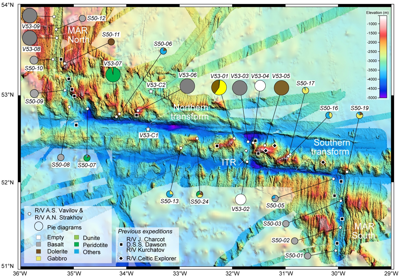
More recently, Expeditions CE15007, CE16014, CE18008 with the R/V Celtic Explorer (Georgiopoulou and CE18008 Scientific Party, 2018) and Expedition S50 with the R/V A.N. Strakhov conducted detailed bathymetric surveys of the entire Fracture Zone, including the adjacent southern and northern MAR segments (Fig. 3; Skolotnev et al., 2021). The new surveys show the widespread occurrence of corrugated surfaces exposing lower crust and mantle material, also called “megamullions” or oceanic core complexes (OCCs). These structures are mainly located in the domain bordered by the two fracture zones, on both sides of the intra-transform spreading axis. The widespread occurrence of OCCs indicates that crustal accretion at the intra-transform spreading segment (ITR) is mainly driven by tectonic processes associated to lower crustal exhumation, with no evidence of long-lived magmatic activity typical of a volcanic seafloor (Skolotnev et al., 2021).
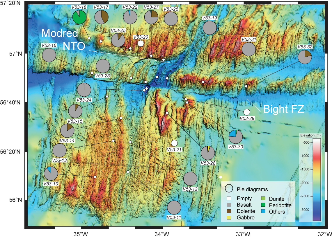
In this study, we present new data collected during cruise V53 with the R/V Akademik Sergey Vavilov in September and October 2021. Based on existing bathymetric data, we here provide a comprehensive view of the rocks exposed in the vicinity of the Bight fracture zone (FZ), including dome-shaped structures located along the northern wall of the Modred NTO and reliefs east of the present-day spreading axis south-east of the Bight active transform fault. Basalts of different ages sampled along single flow lines will provide a temporal evolution of the magmatism in the area.
Our new sampling is of particular interest considering the lack of samples reported to date in the Bight FZ. In addition, we provide here a more complete view of the lithologies exposed in the Charlie Gibbs FZ, covering several gaps of the last sampling cruises. Our new data also include a geophysical survey that acquired high-resolution magnetic profiles in the Bight FZ. These new data are used here to compare the large-scale structure and the geodynamic evolution of these transform domains, with detailed petrological characterizations and geodynamic reconstructions.
![]()
Gravity
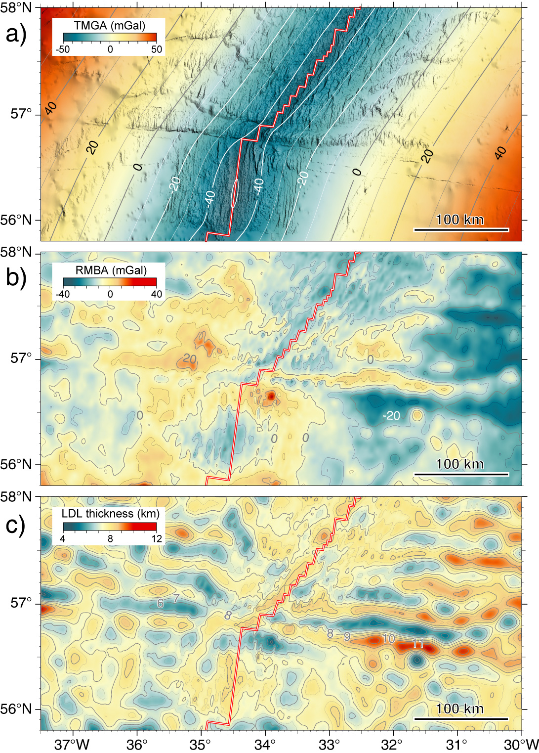
Bight fracture Zone - Free-Air & MBA gravity anomalies

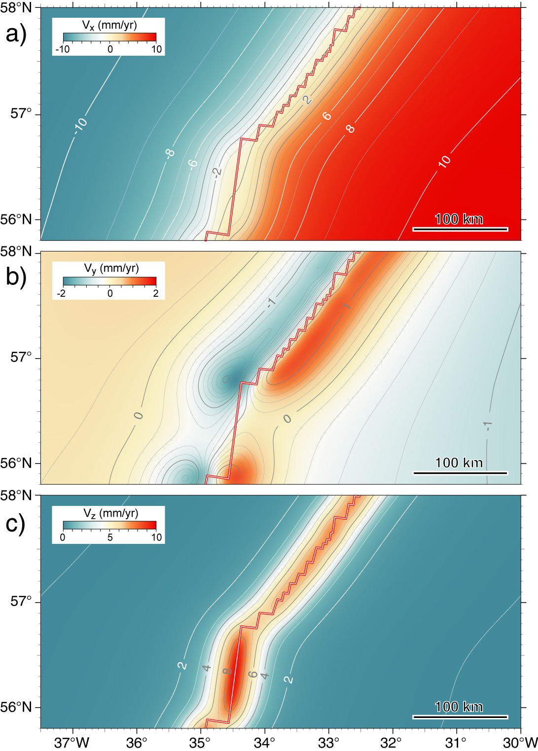
Bight fracture Zone - Mantle flow velocity components
Bight fracture Zone - Thermal & Residual gravity anomalies. Crustal thickness
Rock Sampling
Bight fracture zone - Sampling sites
Charlie Gibbs fracture zone - Sampling sites
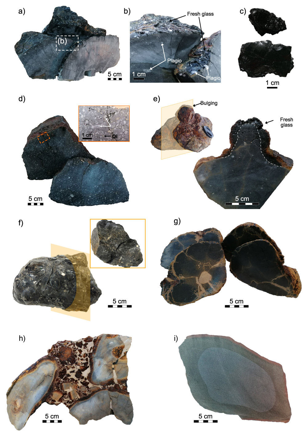
Volcanic rocks
Gabbros
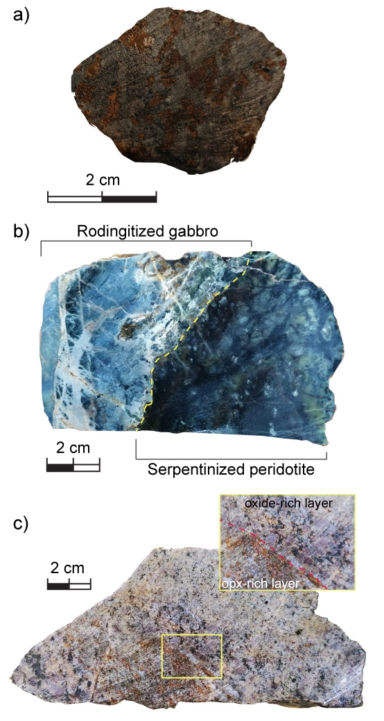
Ultramafics
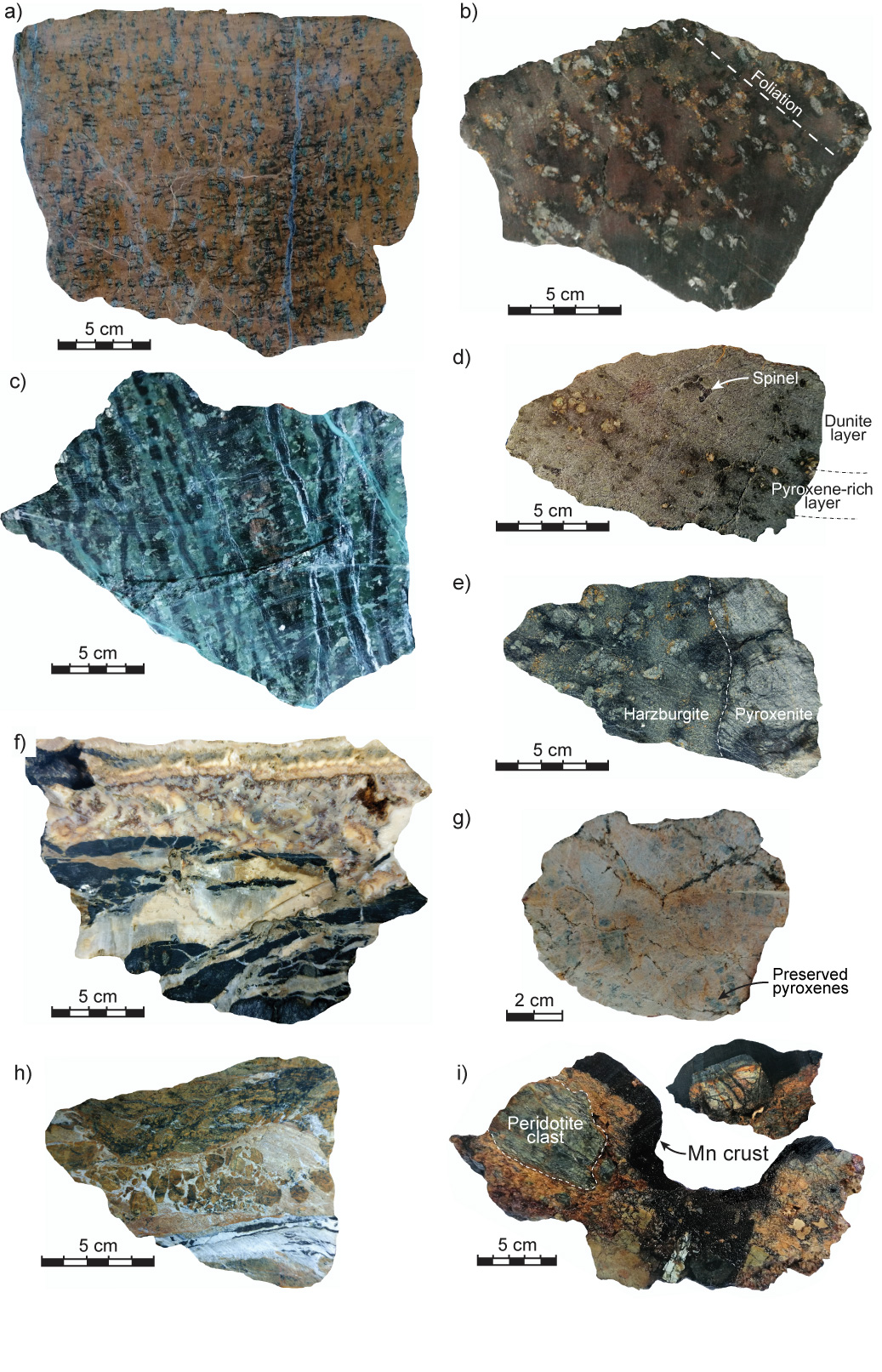
Sedimentary rocks
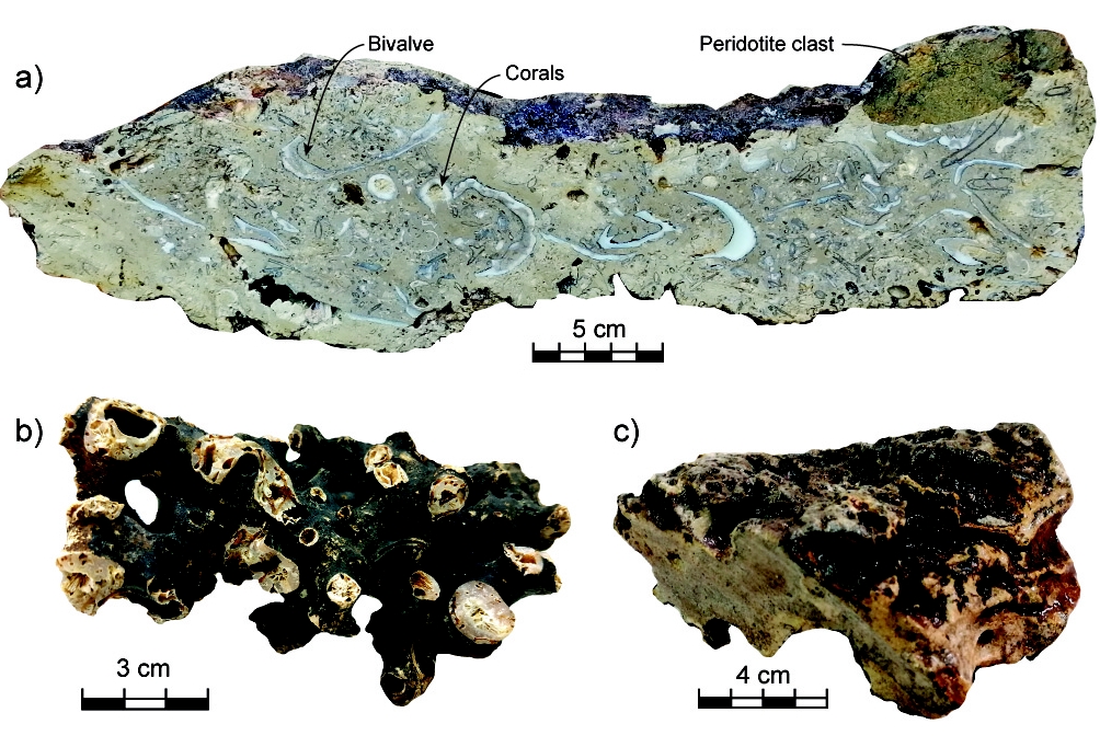
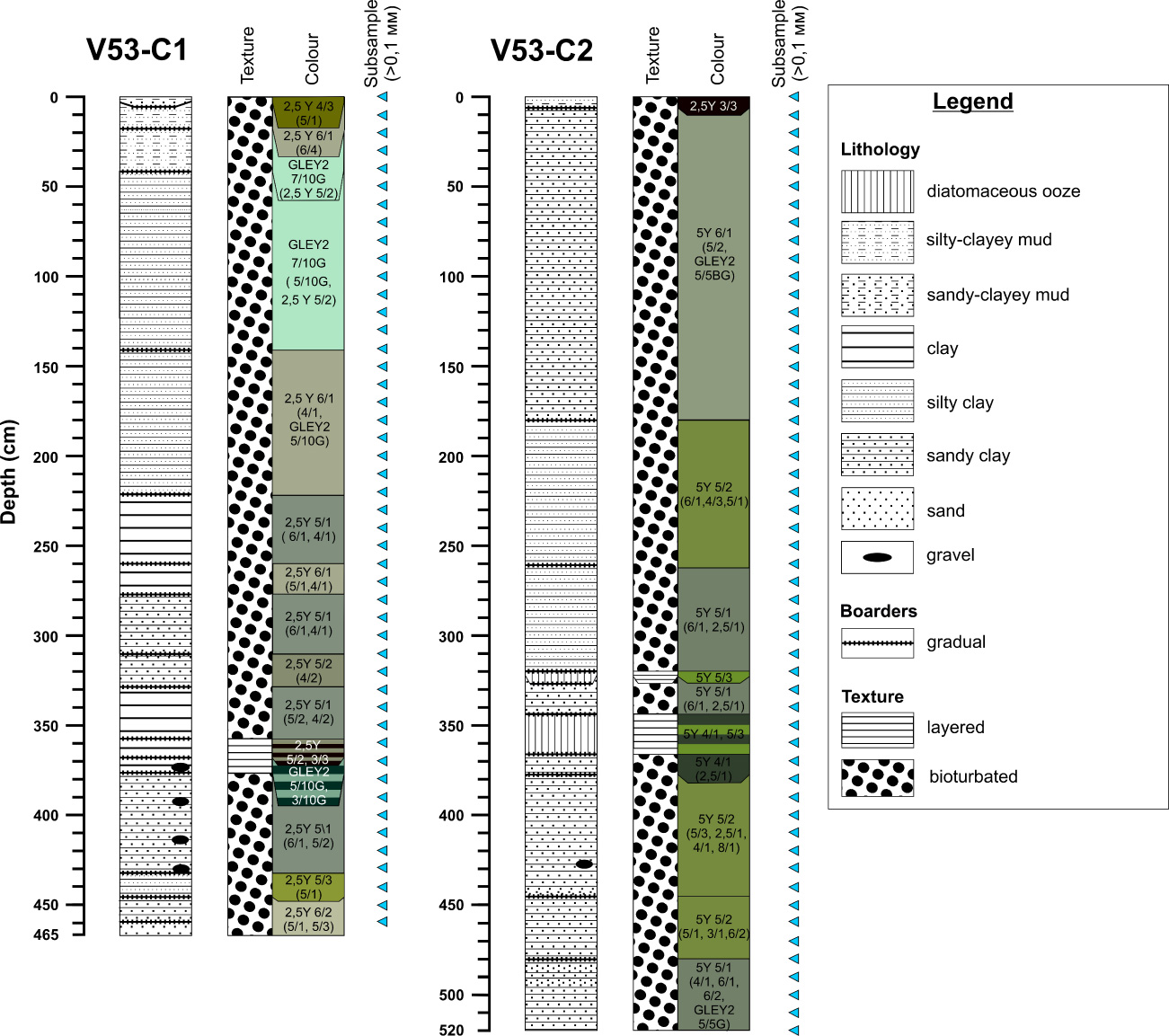
Coring