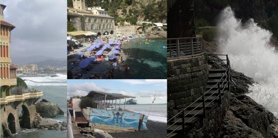
The coastal strip is one of the areas of the planet with the greatest environmental diversity and represents one of the areas most vulnerable to climate change and natural hazards, where morphogenetic processes of marine, terrestrial, atmospheric, and anthropic origin interact. Risks include flooding, erosion, sea level rise and extreme weather events.
Some of the most productive and biodiverse ecosystems are concentrated on the border between land and oceans. However, this heritage is under threat: the areas included within 200 km of the coastline, in fact, while representing only about 20% of the earth's surface, are the areas where more than half of the planet's inhabitants reside.
The importance, complexity and vulnerability of ecosystems and the multiplicity of anthropic uses make coasts particularly important for environmental management and the application of the dictates of sustainable development. This awareness has led to overcoming the sectoral approach towards a systemic vision, which has resulted in the so-called Integrated Coastal Zone Management (ICZM) which unites the different levels of government, the community, science and management, sectoral and public interests in the preparation and implementation of programs for the protection and sustainable development of coastal resources and environments.
Within the theme, DISTAV researchers carry out multiple research activities, including:
1. Sustainable management of resources and activities associated related to their withdrawal with assessment of the level of sustainability through the application of systemic methodologies (e.g. emergy analysis, ecological footprint, LCA) and formulation of scenarios (C. Paoli, P. Povero, P. Vassallo)
2. Decision support systems for the analysis of alternative management strategies (C. Paoli, P. Povero, P. Vassallo).
3. Coastal dynamics studies applied to the evaluation of erosion phenomena, to the defense of the coasts also with the use of dedicated numerical models. Evaluation of the effectiveness of nourishments in relation to methods of pouring, texture, composition (M. Ferrari).
4. Identification of the vulnerability of the coast to marine flooding, through the evaluation of the typology of the physical processes that have determined the damage and understanding of the causes according to the characteristics of the wave motion, the exposure of the coastal stretch and the structural aspects of the damaged elements. Evaluation of the resilience of beaches: capacity and recovery times, new structure (M. Ferrari).
5. Analysis of the conditions of instability/reatriting of the rocky coasts and of the relative geomorphological risk in relation to the coastal vulnerability, with the application of classifications and zoning of the sea cliffs deriving from an integrated survey and interpretation of geological/geomorphological data both of the emerged and submerged areas and meteo marine climate data in relation to the action of the incident wave motion. Identification of interventions for risk mitigation. (P. Brandolini; A. Cevasco, G. Pepe).
6. Geochemical characterization of coastal waters through adaptive in-sut sampling techniques by ROV and/or floating platform and real-time geochemical speciation (M. Vetuschi Zuccolini).
7. Geochemical cartography of sediments in coastal hydrographic basins aimed at evaluating the admissible concentrations in coastal deposits subjected to beach nourishment (M. Vetuschi Zuccolini).