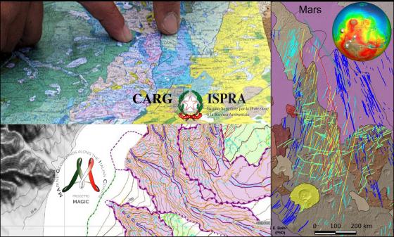
Geological mapping of Earth - inland and seafloor - and of other planets
The Research Team is involved in studies for the geological and structural mapping of Earth (covering inland and seafloor areas) and other planets in the framework of national and international projects. Geological maps are realized through traditional field mapping, oceanographic and marine geophisics campaigns, analysis of remotely-sensed images and are accompanied by digital supports and realized in GIS environment. (Projects: CARG-ISPRA, CGR-Regione Liguria, MaGIC-CNR, GIGAMAP-PNRA, GEOMAP-SCAR, EMODNET-Geology, METIQ).
In detail, researchers are and have been involved in various activities, as such:
- Geological and structural mapping of orogenic belts, ophiolites, igneous and metamorphic basements, and sedimentary units (e.g.: Western Alps, Northern Apennines, Sardinia, Antarctica) - L. Crispini, F. Elter, L. Federico, M. Piazza;
- Geological and structural mapping of the seafloor (e.g.: Mediterranean Sea and Pacific Ocean) - L. Crispini, D. Morelli;
- Analysis of historical geological maps: for studies on the evolution of the Geological thought, for studies on the provenance of geo-paleontological materials of national and international relevance - L. Federico, M. Piazza;
- Remote sensing of planetary surfaces and realization of geological and tectonic maps (e.g. Mars, Ganymede)- P. Cianfarra.
Further info at: https://distav.unige.it/en/labs
Geothematic mapping applied to the territory
This research topic involves the collection of a wide spectrum of geological data (e.g., engineering-geological, geomorphological and geochemical) through field survey and remote sensing and their processing in GIS environment to produce maps useful for territorial planning and management along with the protection of its natural resources. The activities of the department's researchers are mainly focused on the development of the following thematic maps:
- Geomorphological maps and derived thematic maps - e.g., landslides inventory maps, land use maps, maps of coastal landforms and processes; maps of anthropogenic landforms and deposits (P. Brandolini, A. Cevasco, F. Faccini, M. Ferrari, A. Mandarino, G. Pepe, I. Rellini).
- Landslide susceptibility zoning maps (P. Brandolini, A. Cevasco, F. Faccini, G. Pepe, I. Rellini).
- Pedological maps - e.g., land capacity, soil erodibility, organic carbon content (I. Rellini).
- Engineering-geological and hydrogeological maps (A. Cevasco, G. Pepe).
- Geochemical maps of geological matrices involved in subsurface and aquifer dynamic processes with particular interest in regulatory use (M. Vetuschi Zuccolini).